Swiss Soil Dataset

The Swiss Soil Information System NABODAT contains soil data from cantonal soil protection offices and some national projects. An extract of approved data can be requested with the Swiss Soil Dataset (V6, April 2022).

Swiss Soil Dataset version 6 – Spatial distribution of the locations

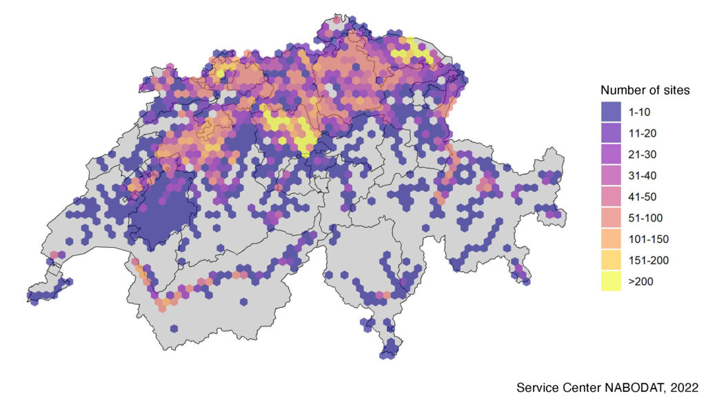
The soil dataset contains point data such as soil information gathered at soil profiles or from soil quality surveys. Spatial soil data such as soil maps or raster data are not part of this dataset. The data set includes various measurements and soil parameters, soil pollutant data are excluded. Most data derive from separate soil mapping projects and is therefore not representative of the entire area of Switzerland. The Swiss Soil Dataset version 6 was updated in April 2022. It contains data from about 33’000 sites.

Please fill out the form below to request the Swiss Soil Dataset.

We recommend consulting the documentation and FAQ accompanying the dataset. Both documents are also part of the data package.

Terms of use

  • The data set is provided without guarantee, without claim to utility for any specific purpose, without claim to be area-representative and without claim to harmonized professional quality. It is submitted only for informational purposes. There is no entitlement to advice regarding the data set.
  • The dataset will be submitted on request. The data recipients will be asked for which purpose they want to obtain the data – this is purely for statistical purposes and should be helpful for planning future data collections.
  • It is recommended to archive the local copy of the data after using the dataset and to request an updated record on future demand.
  • For any use of the data, the source and version of the soil dataset must be accurately referenced.
  • The data should not be disclosed to third parties. Interested parties can make a separate request.